| WILLOUGHBY WARREN & WF |
| WILLOUGHBY SHELLEY |
|
| 2811 NC211 |
|
| LUMBERTON , NC 28358 |
|
| Property
Location Address |
|
| Parcel
Ref No. |
10010103403 |
| PIN |
938367438100 |
| Account
No. |
1201946 |
| Tax
District |
RAFT SWAMP FIRE |
| Land
Use Code |
D-71 |
| Land
Use Desc |
MOBILE HOME W/LAND |
| Subdiv
Code |
|
| Subdiv
Desc |
|
| Neighborhood |
10001 |
|
| Legal
Desc |
WEST SIDE HWY 211 |
| |
0000 00 X 00 |
| Deed
Bk/Pg |
02193 / 0362 |
| Plat
Bk/Pg |
/ |
| |
Sales
Information |
| Grantor |
ANDERSON KENNETH |
| |
|
| Sold
Date |
2019-08-30 |
| Sold
Amount $ |
165,000 |
|
| Market Value $ |
108,100 |
Market
Value - Land and all permanent improvements,
if any, effective January 1, 2010, date
of County’s most recent General Reappraisal
|
|
| Assessed Value $ |
108,100 |
If
Assessed Value not equal Market Value then
subject parcel designated as a special
class -agricultural, horticultural, or
forestland and thereby eligible for taxation
on basis of Present-Use and/or reduction
from a formal appeal procedure
|
|
| Map Acres |
4 |
| Tax District Note |
|
| Present-Use Info |
|
|
| (1st
Major Improvement on Subject
Parcel) |
| Year
Built |
2002 |
| Built
Use/Style |
MOBILE HOME (DOUBLE WIDE) |
| Current
Use |
C+ / |
| * Percent
Complete |
100 |
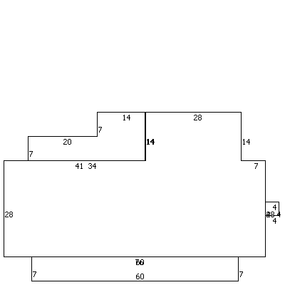
| Heated
Area (S/F) |
2,520 |
| ** Bathroom(s) |
2 Full Bath(s) 0 Half Bath(s) |
| ** Bedroom(s) |
4 |
| Fireplace
(Y/N) |
N |
| Basement
(Y/N) |
N |
| Attached
Garage (Y/N) |
N |
| *** Multiple
Improvements |
001 |
*
Note - As of January 1
*
* Note - Bathroom(s), Bedroom(s), shown for description
only
* * * Note - If multiple improvements equal “MLT” then
parcel includes additional major improvements |
|
| Improvement
Valuation (1st
Major Improvement on Subject Parcel) |
* Improvement
Market Value $ |
** Improvement
Assessed Value $ |
90,700 |
90,700 |
*
Note - Market Value effective Date equal January
1, 2010, date of County’s most recent General
Reappraisal
** Note - If Assessed Value not equal Market Value
then variance resulting from formal appeal procedure |
|
| Land
Value Detail (Effective Date January 1, 2010,
date of County’s most recent General Reappraisal) |
Land Market Value (LMV) $ |
Land Present-Use Value (PUV)
$ ** |
Land Total Assessed Value
$ |
17,400 |
17,400 |
17,400 |
| **
Note: If PUV equal LMV then parcel has
not qualified for present use program |
|
|