|
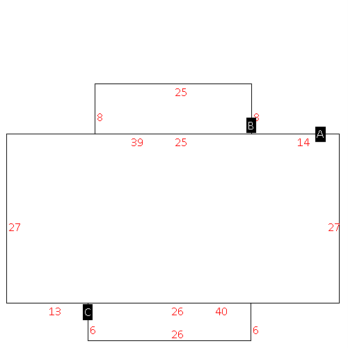
(Building 1) - Sketch for Parcel ID: 3721762439.000
NOTE: Sketches are updated the first day of every month.
 |
| Label |
Description |
Base SF |
Total SF |
| A |
APT-DUPLEX/TRIPLEX |
1456.00 |
1456.00 |
| B |
PORCH-OPEN-FR |
18.00 |
.00 |
| C |
PORCH-OPEN-FR |
144.00 |
.00 |
| D |
PORCH-OPEN-FR |
18.00 |
.00 |
|
|
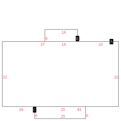
(Building 2) - Sketch for Parcel ID: 3721762439.000
NOTE: Sketches are updated the first day of every month.
 |
| Label |
Description |
Base SF |
Total SF |
| A |
APT-DUPLEX/TRIPLEX |
1456.00 |
1456.00 |
| B |
PORCH-OPEN-FR |
18.00 |
.00 |
| C |
PORCH-OPEN-FR |
144.00 |
.00 |
| D |
PORCH-OPEN-FR |
18.00 |
.00 |
|
|
(Building 3) - Sketch for Parcel ID: 3721762439.000
NOTE: Sketches are updated the first day of every month.
 |
| Label |
Description |
Base SF |
Total SF |
| A |
APT-DUPLEX/TRIPLEX |
1456.00 |
1456.00 |
| B |
PORCH-OPEN-FR |
18.00 |
.00 |
| C |
PORCH-OPEN-FR |
144.00 |
.00 |
| D |
PORCH-OPEN-FR |
18.00 |
.00 |
|
|
(Building 4) - Sketch for Parcel ID: 3721762439.000
NOTE: Sketches are updated the first day of every month.
 |
| Label |
Description |
Base SF |
Total SF |
| A |
APT-DUPLEX/TRIPLEX |
1456.00 |
1456.00 |
| B |
PORCH-OPEN-FR |
18.00 |
.00 |
| C |
PORCH-OPEN-FR |
144.00 |
.00 |
| D |
PORCH-OPEN-FR |
18.00 |
.00 |
|
|
(Building 5) - Sketch for Parcel ID: 3721762439.000
NOTE: Sketches are updated the first day of every month.
 |
| Label |
Description |
Base SF |
Total SF |
| A |
APT-DUPLEX/TRIPLEX |
1456.00 |
1456.00 |
| B |
PORCH-OPEN-FR |
18.00 |
.00 |
| C |
PORCH-OPEN-FR |
144.00 |
.00 |
| D |
PORCH-OPEN-FR |
18.00 |
.00 |
|
|
(Building 6) - Sketch for Parcel ID: 3721762439.000
NOTE: Sketches are updated the first day of every month.
 |
| Label |
Description |
Base SF |
Total SF |
| A |
APT-DUPLEX/TRIPLEX |
1431.00 |
1431.00 |
| B |
PORCH-ENCL-FR |
200.00 |
200.00 |
| C |
PORCH-OPEN-FR |
156.00 |
.00 |
|
|
(Building 7) - Sketch for Parcel ID: 3721762439.000
NOTE: Sketches are updated the first day of every month.
 |
| Label |
Description |
Base SF |
Total SF |
| A |
APT-DUPLEX/TRIPLEX |
1431.00 |
1431.00 |
| B |
PORCH-ENCL-FR |
200.00 |
.00 |
| C |
PORCH-OPEN-FR |
156.00 |
.00 |
|
|
(Building 8) - Sketch for Parcel ID: 3721762439.000
NOTE: Sketches are updated the first day of every month.
 |
| Label |
Description |
Base SF |
Total SF |
| A |
APT-DUPLEX/TRIPLEX |
1431.00 |
1431.00 |
| B |
PORCH-ENCL-FR |
200.00 |
.00 |
| C |
PORCH-OPEN-FR |
156.00 |
.00 |
|
|
(Building 9) - Sketch for Parcel ID: 3721762439.000
NOTE: Sketches are updated the first day of every month.
 |
| Label |
Description |
Base SF |
Total SF |
| A |
APT-DUPLEX/TRIPLEX |
1682.00 |
1682.00 |
| B |
STOOP-MAS |
144.00 |
.00 |
| C |
STOOP-MAS |
96.00 |
.00 |
|
|
(Building 10) - Sketch for Parcel ID: 3721762439.000
NOTE: Sketches are updated the first day of every month.
 |
| Label |
Description |
Base SF |
Total SF |
| A |
APT-DUPLEX/TRIPLEX |
1824.00 |
1824.00 |
| B |
STOOP-MAS |
150.00 |
.00 |
| C |
STOOP-MAS |
150.00 |
.00 |
|
|
(Building 11) - Sketch for Parcel ID: 3721762439.000
NOTE: Sketches are updated the first day of every month.
 |
| Label |
Description |
Base SF |
Total SF |
| A |
APT-DUPLEX/TRIPLEX |
1710.00 |
1710.00 |
| C |
STOOP-MAS |
24.00 |
.00 |
| D |
STOOP-MAS |
150.00 |
.00 |
| E |
STOOP-MAS |
24.00 |
.00 |
|
|
(Building 12) - Sketch for Parcel ID: 3721762439.000
NOTE: Sketches are updated the first day of every month.
 |
| Label |
Description |
Base SF |
Total SF |
| A |
APT-DUPLEX/TRIPLEX |
1824.00 |
1824.00 |
| B |
STOOP-MAS |
96.00 |
.00 |
| C |
STOOP-MAS |
150.00 |
.00 |
|
|
(Building 13) - Sketch for Parcel ID: 3721762439.000
NOTE: Sketches are updated the first day of every month.
 |
| Label |
Description |
Base SF |
Total SF |
| A |
APT-DUPLEX/TRIPLEX |
1824.00 |
1824.00 |
| B |
STOOP-MAS |
96.00 |
.00 |
| C |
STOOP-MAS |
150.00 |
.00 |
|
|
(Building 14) - Sketch for Parcel ID: 3721762439.000
NOTE: Sketches are updated the first day of every month.
 |
| Label |
Description |
Base SF |
Total SF |
| A |
APT-DUPLEX/TRIPLEX |
1824.00 |
1824.00 |
| B |
STOOP-MAS |
20.00 |
.00 |
| C |
STOOP-MAS |
20.00 |
.00 |
|
|
(Building 15) - Sketch for Parcel ID: 3721762439.000
NOTE: Sketches are updated the first day of every month.
 |
| Label |
Description |
Base SF |
Total SF |
| A |
APT-DUPLEX/TRIPLEX |
1824.00 |
1824.00 |
| B |
STOOP-MAS |
96.00 |
.00 |
| C |
STOOP-MAS |
150.00 |
.00 |
|
|
|
