|
|
| PO BOX 10 |
|
| WILSON , NC 27894-0010 |
|
| Property
Location Address |
|
| Parcel
ID No. |
3720861702.000 |
| PIN |
3720 86 1702 000 |
| Owner ID |
1000001 |
| |
|
| Tax
District |
31 - C/CIWI-WILSON |
| |
| Land Use Code |
89 |
| Land Use Desc |
OTHER MUNICIPAL |
| |
|
| Neighborhood |
8383 - WILSON_SOUTH_I-2 |
|
| Legal
Desc |
3100 STANTONSBURG RD SE |
| |
TR-1&4 228.61AC |
| |
|
| Deed
Year Bk/Pg |
2022 - 1075 / 138 |
| Plat
Bk/Pg |
40 / 242 |
| |
Sales
Information |
| |
| Grantor |
|
| |
|
| Sold
Date |
0--0 |
| Sold
Amount $ |
0 |
|
| |
| Market Value $ |
4,365,108
|
| |
|
Market
Value - Land and all permanent improvements,
if any, effective January 1, 2024, date
of County’s most recent General Reappraisal
|
|
| |
|
| Assessed Value $ |
4,365,108
|
| |
If
Assessed Value not equal Market Value then
subject parcel designated as a special
class -agricultural, horticultural, or
forestland and thereby eligible for taxation
on basis of Present-Use.
|
|
|
| Year
Built |
1987 |
| Built
Use/Style |
OTHER MUNICIPAL |
| Grade |
C-10 / |
| * Percent
Complete |
100 |
| Heated
Area (S/F) |
5,071 |
| Fireplace
(Y/N) |
N |
| Basement
(Y/N) |
N |
| ** Bedroom(s) |
0 |
| ** Bathroom(s) |
0 Full Bath(s) 0 Half Bath(s) |
| *** Multiple
Improvements |
003 |
*
Note - As of January 1
*
* Note - Bathroom(s), Bedroom(s), shown for description
only
* * * Note - If multiple improvements equal “MLT” then
parcel includes additional major improvements |
|
| Photo |
|
No Photo for 3720861702.000
|
|
| Building
Sketch - NOTE: Sketches are updated the first day of every month. |
|
(Building 1) - Sketch for Parcel ID: 3720861702.000
NOTE: Sketches are updated the first day of every month.
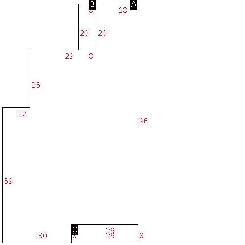 |
| Label |
Description |
Base SF |
Total SF |
| A |
OTHER MUNICIPAL |
4784.00 |
5071.00 |
| B |
PORCH-OPEN-MAS |
160.00 |
.00 |
| C |
PORCH-OPEN-MAS |
232.00 |
.00 |
|
|
(Building 2) - Sketch for Parcel ID: 3720861702.000
NOTE: Sketches are updated the first day of every month.
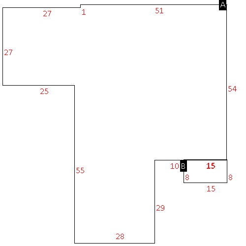 |
| Label |
Description |
Base SF |
Total SF |
| A |
OTHER COUNTY |
4347.00 |
4347.00 |
| B |
UTILITY STG-MAS |
120.00 |
.00 |
|
|
(Building 3) - Sketch for Parcel ID: 3720861702.000
NOTE: Sketches are updated the first day of every month.
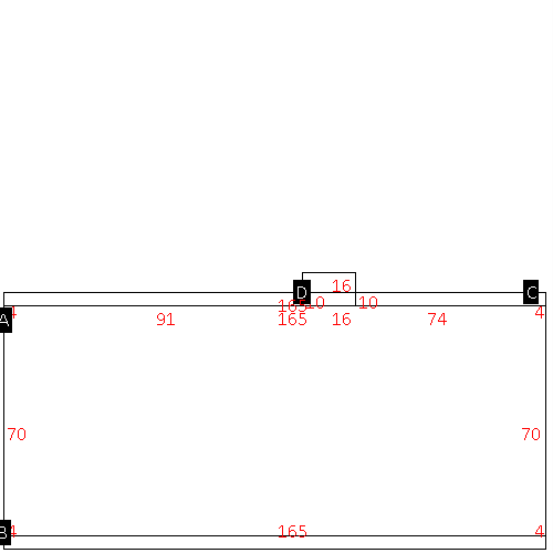 |
| Label |
Description |
Base SF |
Total SF |
| A |
WHSE |
11550.00 |
11550.00 |
| B |
CANOPY W/ SLAB |
660.00 |
.00 |
| C |
CANOPY W/ SLAB |
660.00 |
.00 |
| D |
UNCOV LOAD PLATFORM-AVG |
160.00 |
.00 |
|
|
|
|
|
| Map Acres |
228.61 |
| Tax District Note |
31 - C/CIWI-WILSON |
| Present-Use Info |
OTHER MUNICIPAL |
| Zoning Code |
HI |
| Zoning Desc |
HEAVY INDUSTRIAL |
|
| Total Improvements Valuation
|
*Total Improvements Full Market Value $
|
**Total Improvements Assessed Value
|
2,020,396
|
2,020,396
|
*
Note - Market Value effective Date equal January 1, 2024, date of County’s most recent General
Reappraisal
** Note - If Assessed Value not equal Market Value then variance
resulting from formal appeal procedure |
|
| Land
Value Detail (Effective Date January 1, 2024, date
of County’s most recent General Reappraisal) |
Land
Full Value (LFV) $
|
Land
Present-Use Value (PUV) $ **
|
Land
Total Assessed Value $
|
2,344,712
|
2,344,712
|
2,344,712
|
| **
Note: If PUV equal LMV then parcel has
not qualified for present use program |
|
| Land
Detail (Effective Date January 1, 2024, date of County’s
most recent General Reappraisal) |
Rate Type |
Rate Code |
Description |
Quantity |
AC |
8900 |
OTHER MUNICIPAL |
61.000 |
|
|
|
.000 |
AC |
0121 |
RESIDUAL ACREAGE PAVED |
155.610 |
|
|
|
.000 |
AC |
9500 |
POND/LAKE |
12.000 |
|
|
|
.000 |
|
|
|
|
