| IREIT WILSON MARKETPLACE LLC |
| |
|
| ATTN: PROPERTY TAX DEPT |
PO BOX 3666 |
| OAK BROOK , IL 60522-3666 |
|
| Property
Location Address |
| 3401 2A RALEIGH ROAD PKWY W |
|
| Parcel
ID No. |
3702667770.000 |
| PIN |
3702 66 7770 000 |
| Owner ID |
1108695 |
| |
|
| Tax
District |
31 - C/CIWI-WILSON |
| |
| Land Use Code |
13 |
| Land Use Desc |
DEPARTMENT STORE |
| |
|
| Neighborhood |
8244 - RALEIGH_ROAD_PKWY_B-4 |
|
| Legal
Desc |
3401 2A RALEIGH ROAD PKWY |
| |
TR-1S11 HERITAGE 26.09AC |
| |
|
| Deed
Year Bk/Pg |
2017 - 2686 / 834 |
| Plat
Bk/Pg |
34 / 98 |
| |
Sales
Information |
| |
| Grantor |
SCP-CC HERITAGE CROSSING LLC |
| |
|
| Sold
Date |
2017-02-03 |
| Sold
Amount $ |
0 |
|
| |
| Market Value $ |
23,239,616
|
| |
|
Market
Value - Land and all permanent improvements,
if any, effective January 1, 2024, date
of County’s most recent General Reappraisal
|
|
| |
|
| Assessed Value $ |
23,239,616
|
| |
If
Assessed Value not equal Market Value then
subject parcel designated as a special
class -agricultural, horticultural, or
forestland and thereby eligible for taxation
on basis of Present-Use.
|
|
|
| Year
Built |
2007 |
| Built
Use/Style |
SHOPPING CENTER- STRIP |
| Grade |
C+10 / C+10 GRADE |
| * Percent
Complete |
100 |
| Heated
Area (S/F) |
47,137 |
| Fireplace
(Y/N) |
N |
| Basement
(Y/N) |
N |
| ** Bedroom(s) |
0 |
| ** Bathroom(s) |
0 Full Bath(s) 0 Half Bath(s) |
| *** Multiple
Improvements |
006 |
*
Note - As of January 1
*
* Note - Bathroom(s), Bedroom(s), shown for description
only
* * * Note - If multiple improvements equal “MLT” then
parcel includes additional major improvements |
|
| Photo |
|
No Photo for 3702667770.000
|
|
| Building
Sketch - NOTE: Sketches are updated the first day of every month. |
|
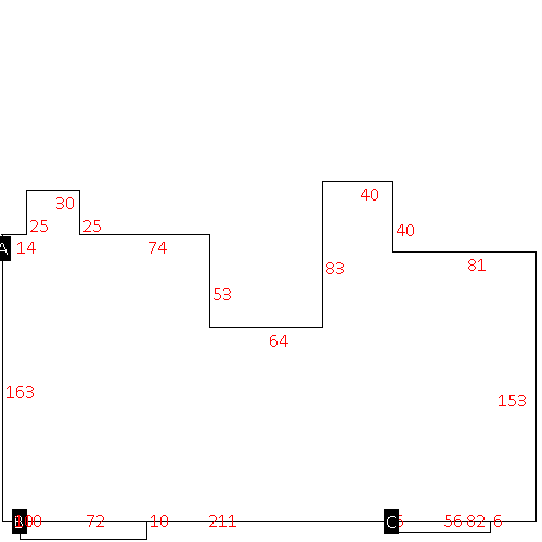
(Building 1) - Sketch for Parcel ID: 3702667770.000
NOTE: Sketches are updated the first day of every month.
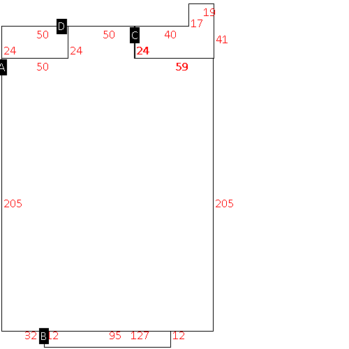 |
| Label |
Description |
Base SF |
Total SF |
| A |
DEPT STORE |
33795.00 |
33795.00 |
| B |
PORCH-OPEN-FR |
1140.00 |
.00 |
| C |
UTILITY STG-FR |
1739.00 |
.00 |
| D |
OFFICE BUILDING |
1200.00 |
1200.00 |
|
|
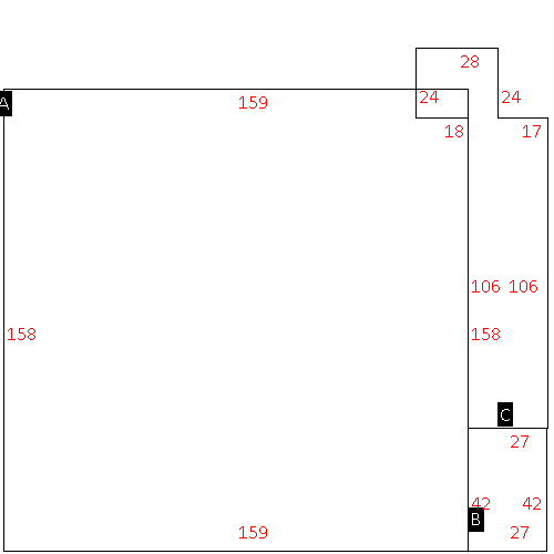
(Building 2) - Sketch for Parcel ID: 3702667770.000
NOTE: Sketches are updated the first day of every month.
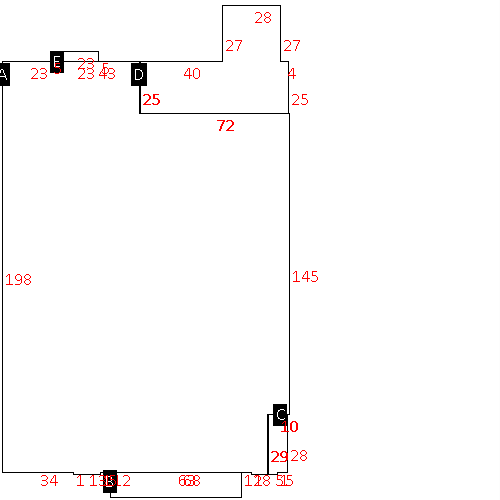 |
| Label |
Description |
Base SF |
Total SF |
| A |
DEPT STORE |
25265.00 |
25265.00 |
| B |
PORCH-OPEN-FR |
756.00 |
.00 |
| C |
OFFICE BUILDING |
285.00 |
285.00 |
| D |
UTILITY STG-FR |
2556.00 |
.00 |
| E |
STOOP-MAS |
115.00 |
.00 |
|
|
(Building 3) - Sketch for Parcel ID: 3702667770.000
NOTE: Sketches are updated the first day of every month.
 |
| Label |
Description |
Base SF |
Total SF |
|
|
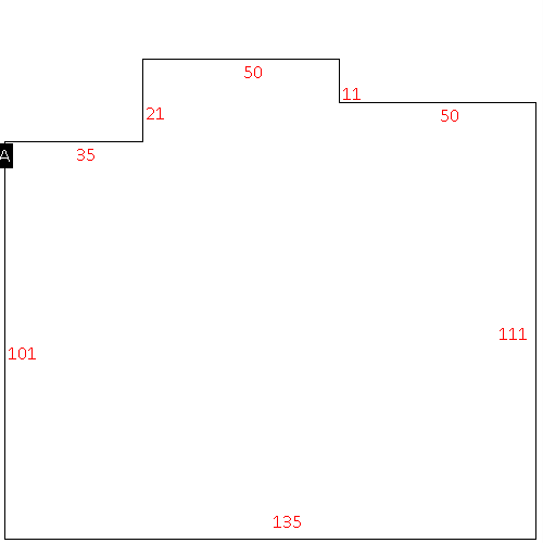
(Building 4) - Sketch for Parcel ID: 3702667770.000
NOTE: Sketches are updated the first day of every month.
 |
| Label |
Description |
Base SF |
Total SF |
| A |
SHOPPING CENTER-STRIP |
15185.00 |
15185.00 |
|
|
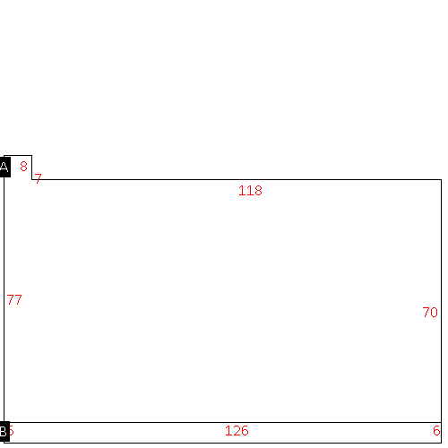
(Building 5) - Sketch for Parcel ID: 3702667770.000
NOTE: Sketches are updated the first day of every month.
 |
| Label |
Description |
Base SF |
Total SF |
| A |
SHOPPING CENTER-STRIP |
8876.00 |
8876.00 |
| B |
CANOPY-ECONOMY |
756.00 |
.00 |
|
|
(Building 6) - Sketch for Parcel ID: 3702667770.000
NOTE: Sketches are updated the first day of every month.
 |
| Label |
Description |
Base SF |
Total SF |
| A |
SHOPPING CENTER-STRIP |
47137.00 |
47137.00 |
| B |
PORCH-OPEN-FR |
720.00 |
.00 |
| C |
PORCH-OPEN-FR |
336.00 |
.00 |
|
|
|
|
|
| Map Acres |
26.09 |
| Tax District Note |
31 - C/CIWI-WILSON |
| Present-Use Info |
DEPARTMENT STORE |
| Zoning Code |
HC |
| Zoning Desc |
HIGHWAY COMMERCIAL |
|
| Total Improvements Valuation
|
*Total Improvements Full Market Value $
|
**Total Improvements Assessed Value
|
15,568,377
|
15,568,377
|
*
Note - Market Value effective Date equal January 1, 2024, date of County’s most recent General
Reappraisal
** Note - If Assessed Value not equal Market Value then variance
resulting from formal appeal procedure |
|
| Land
Value Detail (Effective Date January 1, 2024, date
of County’s most recent General Reappraisal) |
Land
Full Value (LFV) $
|
Land
Present-Use Value (PUV) $ **
|
Land
Total Assessed Value $
|
7,671,239
|
7,671,239
|
7,671,239
|
| **
Note: If PUV equal LMV then parcel has
not qualified for present use program |
|
| Land
Detail (Effective Date January 1, 2024, date of County’s
most recent General Reappraisal) |
Rate Type |
Rate Code |
Description |
Quantity |
SF |
0713 |
DEPT STORE |
999999.000 |
|
|
|
.000 |
SF |
0713 |
DEPT STORE |
136481.000 |
|
|
|
.000 |
|
|
|
|
