| ALLIANCE ONE NORTH AMERICA LLC |
| |
|
| PO BOX 166 |
|
| FARMVILLE , NC 27828-0166 |
|
| Property
Location Address |
|
| Parcel
ID No. |
3720980830.000 |
| PIN |
3720 98 0830 000 |
| Owner ID |
1116131 |
| |
|
| Tax
District |
31 - C/CIWI-WILSON |
| |
| Land Use Code |
17 |
| Land Use Desc |
OFFICE |
| |
|
| Neighborhood |
8383 - WILSON_SOUTH_I-2 |
|
| Legal
Desc |
2400 STANTONSBURG RD SE |
| |
101.30AC |
| |
|
| Deed
Year Bk/Pg |
2019 - 2779 / 539 |
| Plat
Bk/Pg |
/ |
| |
Sales
Information |
| |
| Grantor |
ALLIANCE ONE INTERNATIONAL INC |
| |
|
| Sold
Date |
2019-04-01 |
| Sold
Amount $ |
0 |
|
| |
| Market Value $ |
13,619,797
|
| |
|
Market
Value - Land and all permanent improvements,
if any, effective January 1, 2024, date
of County’s most recent General Reappraisal
|
|
| |
|
| Assessed Value $ |
13,619,797
|
| |
If
Assessed Value not equal Market Value then
subject parcel designated as a special
class -agricultural, horticultural, or
forestland and thereby eligible for taxation
on basis of Present-Use.
|
|
|
| Year
Built |
1974 |
| Built
Use/Style |
WAREHOUSE |
| Grade |
C+10 / |
| * Percent
Complete |
100 |
| Heated
Area (S/F) |
400,000 |
| Fireplace
(Y/N) |
N |
| Basement
(Y/N) |
N |
| ** Bedroom(s) |
0 |
| ** Bathroom(s) |
0 Full Bath(s) 0 Half Bath(s) |
| *** Multiple
Improvements |
012 |
*
Note - As of January 1
*
* Note - Bathroom(s), Bedroom(s), shown for description
only
* * * Note - If multiple improvements equal “MLT” then
parcel includes additional major improvements |
|
| Photo |
Photo 1
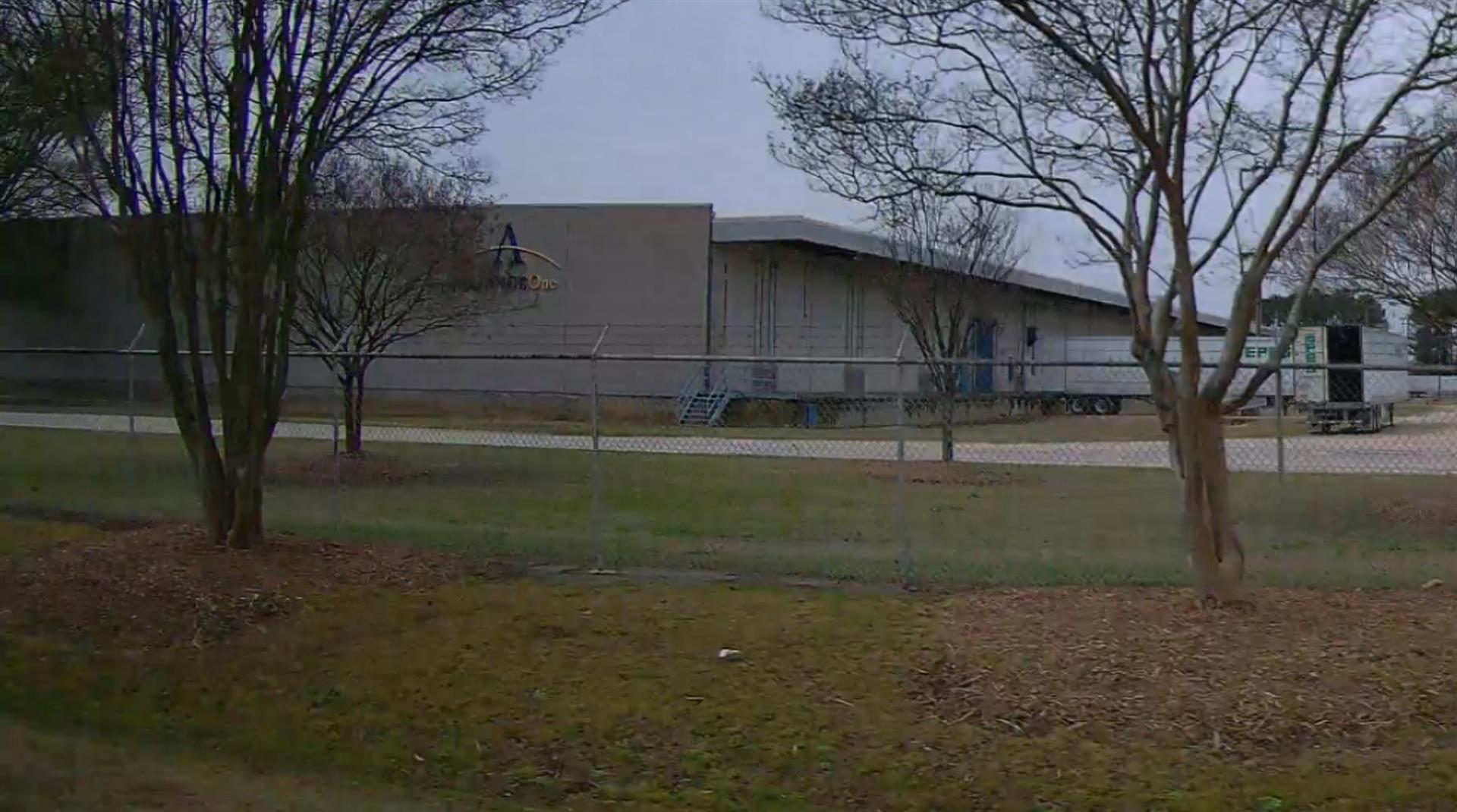 Photo 2
 Photo 3
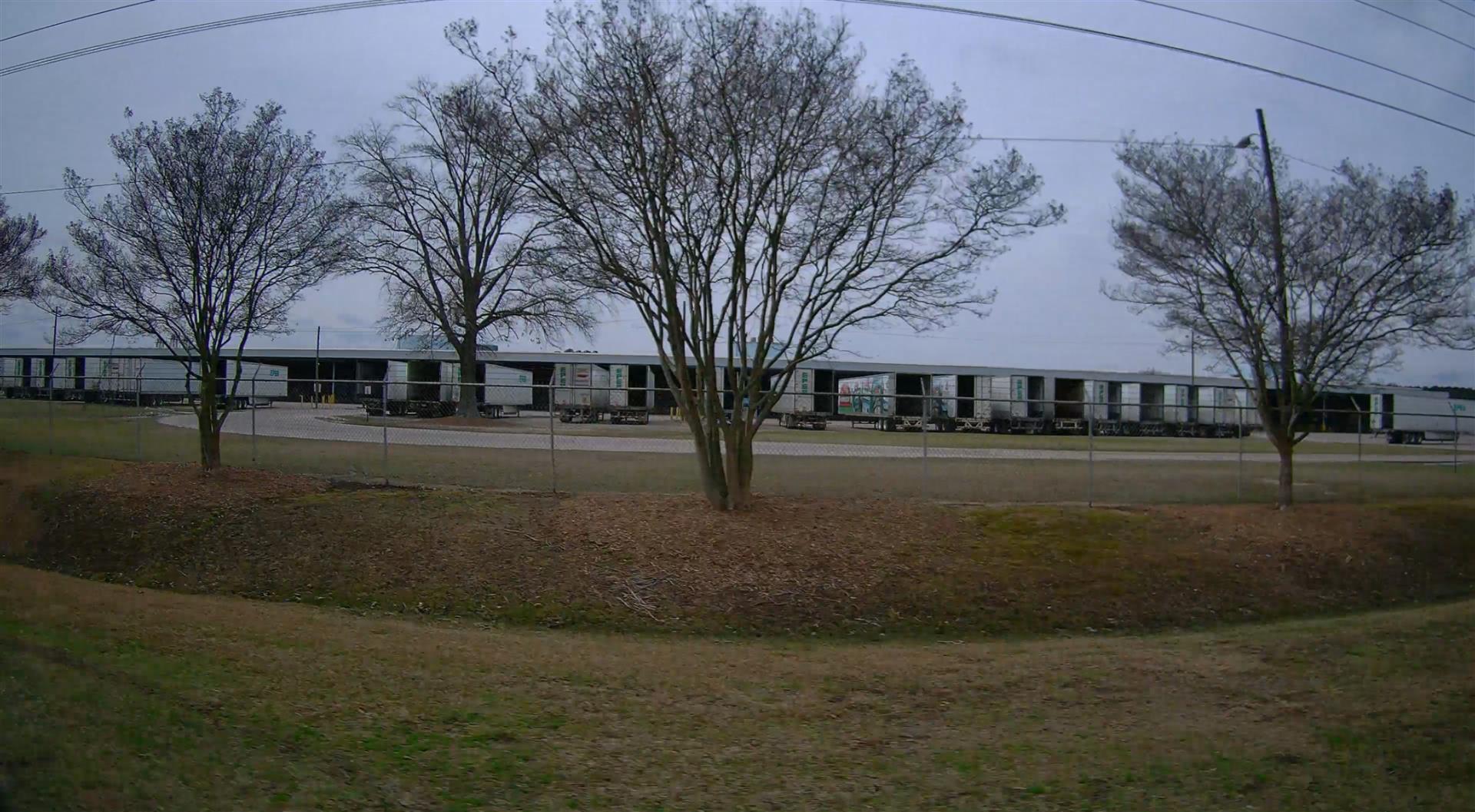 Photo 4
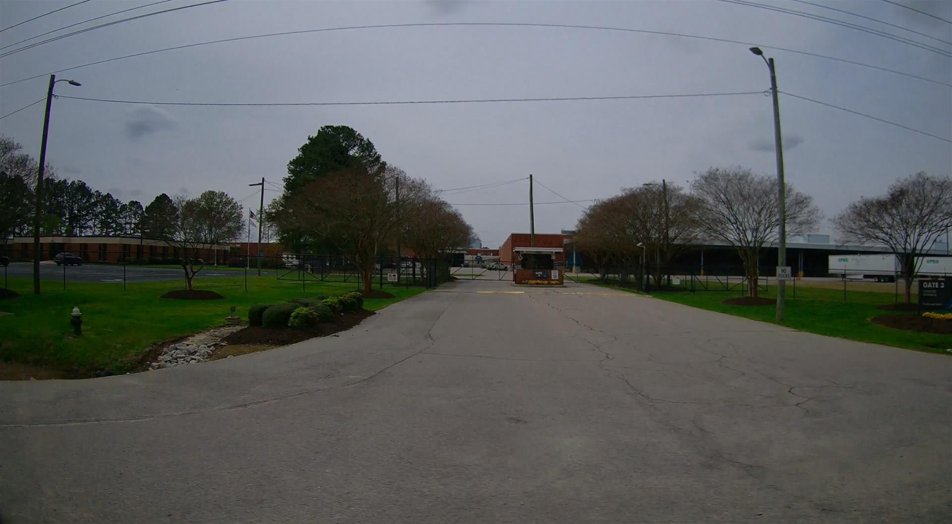 Photo 5
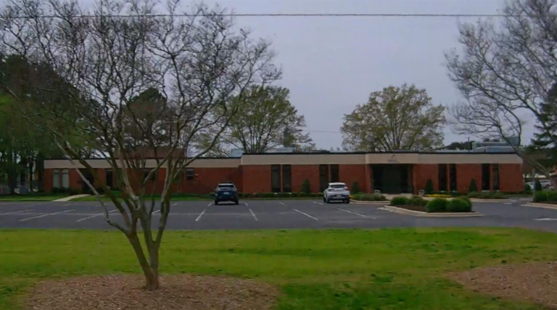 Photo 6
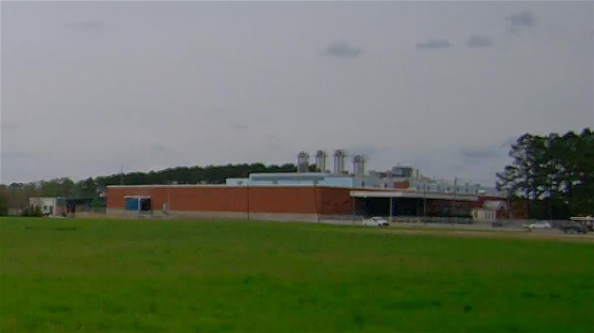
|
|
| Building
Sketch - NOTE: Sketches are updated the first day of every month. |
|
(Building 1) - Sketch for Parcel ID: 3720980830.000
NOTE: Sketches are updated the first day of every month.
 |
| Label |
Description |
Base SF |
Total SF |
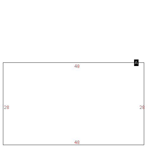
| A |
OFFICE BUILDING |
21000.00 |
21000.00 |
|
|
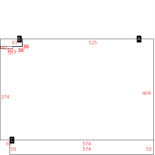
(Building 2) - Sketch for Parcel ID: 3720980830.000
NOTE: Sketches are updated the first day of every month.
 |
| Label |
Description |
Base SF |
Total SF |
| A |
WHSE |
106981.00 |
106981.00 |
| B |
GARAGE-ATT-FR |
9900.00 |
.00 |
| C |
LOAD PLATFORM,CAN-GOOD |
9570.00 |
.00 |
| D |
LOAD PLATFORM,CAN-GOOD |
6400.00 |
.00 |
|
|
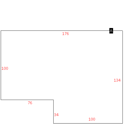
(Building 3) - Sketch for Parcel ID: 3720980830.000
NOTE: Sketches are updated the first day of every month.
 |
| Label |
Description |
Base SF |
Total SF |
| A |
WHSE |
400000.00 |
400000.00 |
| B |
LOAD PLATFORM,CAN-AVG |
5600.00 |
.00 |
| C |
UTILITY STG-FR |
7700.00 |
.00 |
| D |
LOAD PLATFORM,CAN-AVG |
30000.00 |
.00 |
| E |
LOAD PLATFORM,CAN-AVG |
12000.00 |
.00 |
|
|
(Building 4) - Sketch for Parcel ID: 3720980830.000
NOTE: Sketches are updated the first day of every month.
 |
| Label |
Description |
Base SF |
Total SF |
| A |
WHSE |
244638.00 |
244638.00 |
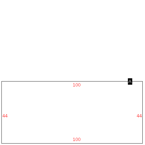
| B |
OFFICE BUILDING |
3051.00 |
3051.00 |
| C |
LOAD PLATFORM,CAN-GOOD |
33292.00 |
.00 |
|
|
(Building 5) - Sketch for Parcel ID: 3720980830.000
NOTE: Sketches are updated the first day of every month.
 |
| Label |
Description |
Base SF |
Total SF |
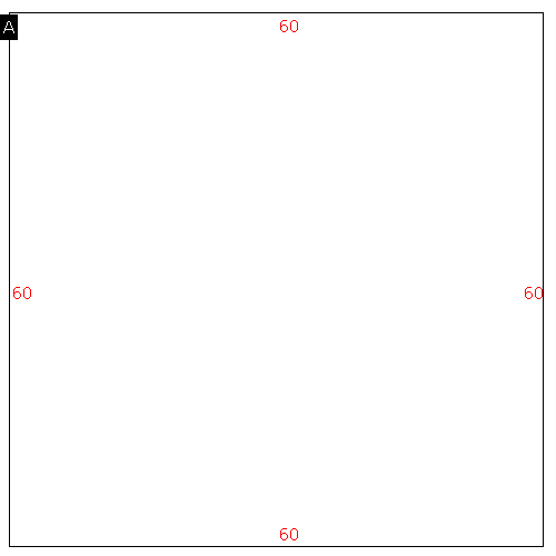
| A |
INDUSTRIAL-LIGHT |
126028.00 |
126028.00 |
| B |
LOAD PLATFORM,CAN-AVG |
7716.00 |
.00 |
| C |
OFFICE BUILDING |
1880.00 |
1880.00 |
|
|
(Building 6) - Sketch for Parcel ID: 3720980830.000
NOTE: Sketches are updated the first day of every month.
 |
| Label |
Description |
Base SF |
Total SF |
| A |
INDUSTRIAL-LIGHT |
137821.00 |
137821.00 |
| B |
LOAD PLATFORM,CAN-AVG |
4752.00 |
.00 |
| C |
OFFICE BUILDING |
2312.00 |
2312.00 |
| D |
PORCH-OPEN-FR |
160.00 |
.00 |
| E |
LOAD PLATFORM,CAN-AVG |
5152.00 |
.00 |
|
|
(Building 7) - Sketch for Parcel ID: 3720980830.000
NOTE: Sketches are updated the first day of every month.
 |
| Label |
Description |
Base SF |
Total SF |
| A |
UTILITIES |
5280.00 |
5280.00 |
|
|
(Building 8) - Sketch for Parcel ID: 3720980830.000
NOTE: Sketches are updated the first day of every month.
 |
| Label |
Description |
Base SF |
Total SF |
| A |
WHSE |
60000.00 |
60000.00 |
| B |
LOAD PLATFORM,CAN-AVG |
1200.00 |
.00 |
| C |
LOAD PLATFORM,CAN-AVG |
5800.00 |
.00 |
|
|
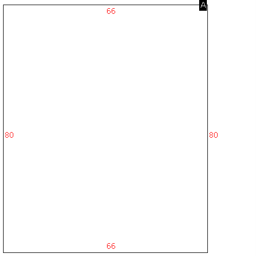
(Building 9) - Sketch for Parcel ID: 3720980830.000
NOTE: Sketches are updated the first day of every month.
 |
| Label |
Description |
Base SF |
Total SF |
| A |
UTILITIES |
1344.00 |
1344.00 |
|
|
(Building 10) - Sketch for Parcel ID: 3720980830.000
NOTE: Sketches are updated the first day of every month.
 |
| Label |
Description |
Base SF |
Total SF |
| A |
WHSE |
80000.00 |
80000.00 |
| B |
LOADING PLATFORM |
4800.00 |
.00 |
| C |
CANOPY-AVERAGE |
3200.00 |
.00 |
| D |
LOADING PLATFORM |
4800.00 |
.00 |
| E |
CANOPY-AVERAGE |
7200.00 |
.00 |
|
|
(Building 11) - Sketch for Parcel ID: 3720980830.000
NOTE: Sketches are updated the first day of every month.
 |
| Label |
Description |
Base SF |
Total SF |
| A |
WHSE |
4400.00 |
4400.00 |
|
|
(Building 12) - Sketch for Parcel ID: 3720980830.000
NOTE: Sketches are updated the first day of every month.
 |
| Label |
Description |
Base SF |
Total SF |
| A |
WHSE |
3600.00 |
3600.00 |
|
|
|
|
|
| Map Acres |
101.3 |
| Tax District Note |
31 - C/CIWI-WILSON |
| Present-Use Info |
OFFICE |
| Zoning Code |
HI |
| Zoning Desc |
HEAVY INDUSTRIAL |
|
| Total Improvements Valuation
|
*Total Improvements Full Market Value $
|
**Total Improvements Assessed Value
|
11,040,877
|
11,040,877
|
*
Note - Market Value effective Date equal January 1, 2024, date of County’s most recent General
Reappraisal
** Note - If Assessed Value not equal Market Value then variance
resulting from formal appeal procedure |
|
| Land
Value Detail (Effective Date January 1, 2024, date
of County’s most recent General Reappraisal) |
Land
Full Value (LFV) $
|
Land
Present-Use Value (PUV) $ **
|
Land
Total Assessed Value $
|
2,578,920
|
2,578,920
|
2,578,920
|
| **
Note: If PUV equal LMV then parcel has
not qualified for present use program |
|
| Land
Detail (Effective Date January 1, 2024, date of County’s
most recent General Reappraisal) |
Rate Type |
Rate Code |
Description |
Quantity |
AC |
0600 |
INDUSTRIAL |
80.000 |
|
|
|
.000 |
AC |
0121 |
RESIDUAL ACREAGE PAVED |
21.300 |
|
|
|
.000 |
|
|
|
|
