| WESTWOOD VILLAGE LIMITED |
| PARTNERSHIP |
|
| PO BOX 3239 |
|
| WILSON , NC 27895 |
|
| Property
Location Address |
|
| Parcel
ID No. |
3712126858.000 |
| PIN |
3712 12 6858 000 |
| Owner ID |
69923691 |
| |
|
| Tax
District |
31 - C/CIWI-WILSON |
| |
| Land Use Code |
16 |
| Land Use Desc |
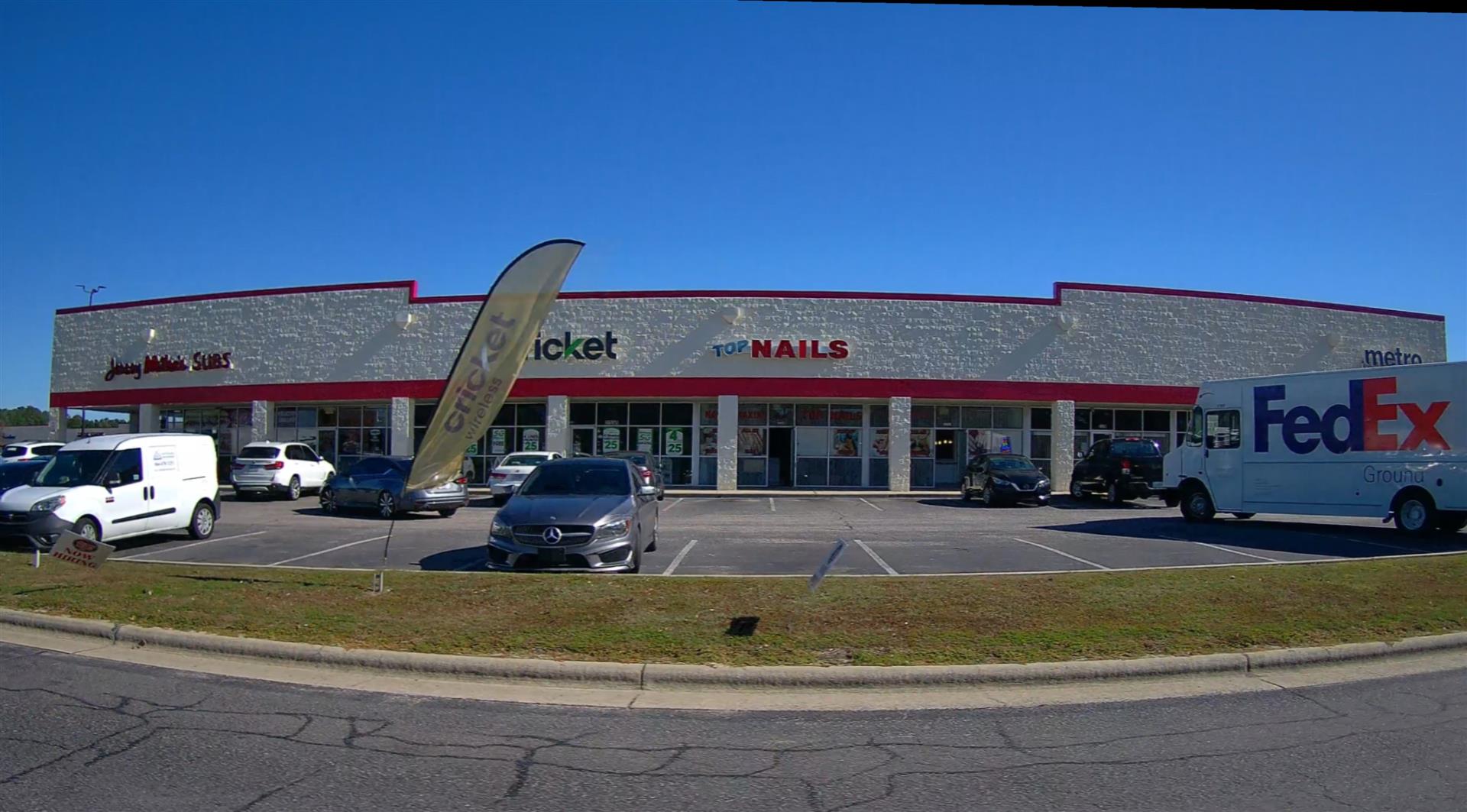
SHOPPING CENTER-STRIP |
| |
|
| Neighborhood |
8244 - RALEIGH_ROAD_PKWY_B-4 |
|
| Legal
Desc |
2348 FOREST HILLS RD W |
| |
11.89AC |
| |
|
| Deed
Year Bk/Pg |
2010 - 2393 / 578 |
| Plat
Bk/Pg |
/ |
| |
Sales
Information |
| |
| Grantor |
|
| |
|
| Sold
Date |
0--0 |
| Sold
Amount $ |
0 |
|
| |
| Market Value $ |
12,092,561
|
| |
|
Market
Value - Land and all permanent improvements,
if any, effective January 1, 2024, date
of County’s most recent General Reappraisal
|
|
| |
|
| Assessed Value $ |
12,092,561
|
| |
If
Assessed Value not equal Market Value then
subject parcel designated as a special
class -agricultural, horticultural, or
forestland and thereby eligible for taxation
on basis of Present-Use.
|
|
|
| Year
Built |
1996 |
| Built
Use/Style |
SHOPPING CENTER- STRIP |
| Grade |
B-05 / B-05 GRADE |
| * Percent
Complete |
100 |
| Heated
Area (S/F) |
47,680 |
| Fireplace
(Y/N) |
N |
| Basement
(Y/N) |
N |
| ** Bedroom(s) |
0 |
| ** Bathroom(s) |
0 Full Bath(s) 0 Half Bath(s) |
| *** Multiple
Improvements |
004 |
*
Note - As of January 1
*
* Note - Bathroom(s), Bedroom(s), shown for description
only
* * * Note - If multiple improvements equal “MLT” then
parcel includes additional major improvements |
|
| Building
Sketch - NOTE: Sketches are updated the first day of every month. |
|
(Building 1) - Sketch for Parcel ID: 3712126858.000
NOTE: Sketches are updated the first day of every month.
 |
| Label |
Description |
Base SF |
Total SF |
| A |
SHOPPING CENTER-STRIP |
47680.00 |
47680.00 |
| B |
PORCH-OPEN-FR |
2090.00 |
.00 |
| C |
PORCH-OPEN-FR |
230.00 |
.00 |
| D |
PORCH-OPEN-FR |
2450.00 |
.00 |
|
|
(Building 2) - Sketch for Parcel ID: 3712126858.000
NOTE: Sketches are updated the first day of every month.
 |
| Label |
Description |
Base SF |
Total SF |
| A |
SHOPPING CENTER-STRIP |
12560.00 |
12560.00 |
| B |
PORCH-OPEN-MAS |
444.00 |
.00 |
|
|
(Building 3) - Sketch for Parcel ID: 3712126858.000
NOTE: Sketches are updated the first day of every month.
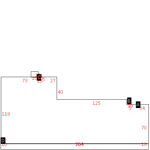 |
| Label |
Description |
Base SF |
Total SF |
| A |
SHOPPING CENTER-STRIP |
24505.00 |
24505.00 |
| B |
UTILITY STG-FR |
45.00 |
.00 |
| C |
UNCOV LOAD PLATFORM-AVG |
160.00 |
.00 |
| D |
PORCH-OPEN-MAS |
2640.00 |
.00 |
|
|
(Building 4) - Sketch for Parcel ID: 3712126858.000
NOTE: Sketches are updated the first day of every month.
 |
| Label |
Description |
Base SF |
Total SF |
| A |
SHOPPING CENTER-STRIP |
20160.00 |
20160.00 |
| B |
UNCOV LOAD PLATFORM-AVG |
400.00 |
.00 |
| C |
PORCH-OPEN-MAS |
323.00 |
.00 |
| D |
PORCH-ENCL-GL |
336.00 |
336.00 |
| E |
PORCH-OPEN-MAS |
323.00 |
.00 |
|
|
|
|
|
| Map Acres |
11.89 |
| Tax District Note |
31 - C/CIWI-WILSON |
| Present-Use Info |
SHOPPING CENTER-STRIP |
| Zoning Code |
HC |
| Zoning Desc |
HIGHWAY COMMERCIAL |
|
| Total Improvements Valuation
|
*Total Improvements Full Market Value $
|
**Total Improvements Assessed Value
|
8,052,720
|
8,052,720
|
*
Note - Market Value effective Date equal January 1, 2024, date of County’s most recent General
Reappraisal
** Note - If Assessed Value not equal Market Value then variance
resulting from formal appeal procedure |
|
| Land
Value Detail (Effective Date January 1, 2024, date
of County’s most recent General Reappraisal) |
Land
Full Value (LFV) $
|
Land
Present-Use Value (PUV) $ **
|
Land
Total Assessed Value $
|
4,039,841
|
4,039,841
|
4,039,841
|
| **
Note: If PUV equal LMV then parcel has
not qualified for present use program |
|
| Land
Detail (Effective Date January 1, 2024, date of County’s
most recent General Reappraisal) |
Rate Type |
Rate Code |
Description |
Quantity |
SF |
0716 |
SHOPPING CENTER-STRIP |
517928.400 |
|
|
|
.000 |
|
|
|
|