| YOUTH ENRICHMENT PROGRAM OF |
| WILSON INC |
|
| 1004 HERRING AV E |
|
| WILSON , NC 27893 |
|
| Property
Location Address |
|
| Parcel
ID No. |
3722823743.000 |
| PIN |
3722 82 3743 000 |
| Owner ID |
69927595 |
| |
|
| Tax
District |
31 - C/CIWI-WILSON |
| |
| Land Use Code |
41 |
| Land Use Desc |
LIGHT MANUFACTURING |
| |
|
| Neighborhood |
8341 - US_301-NC_42_I-1 |
|
| Legal
Desc |
1004 HERRING AVE E |
| |
9.13AC |
| |
|
| Deed
Year Bk/Pg |
2000 - 1769 / 408 |
| Plat
Bk/Pg |
38 / 266 |
| |
Sales
Information |
| |
| Grantor |
|
| |
|
| Sold
Date |
0--0 |
| Sold
Amount $ |
0 |
|
| |
| Market Value $ |
10,505,826
|
| |
|
Market
Value - Land and all permanent improvements,
if any, effective January 1, 2024, date
of County’s most recent General Reappraisal
|
|
| |
|
| Assessed Value $ |
10,505,826
|
| |
If
Assessed Value not equal Market Value then
subject parcel designated as a special
class -agricultural, horticultural, or
forestland and thereby eligible for taxation
on basis of Present-Use.
|
|
|
| Year
Built |
2019 |
| Built
Use/Style |
SCHOOL- PUBLIC |
| Grade |
C / C GRADE |
| * Percent
Complete |
100 |
| Heated
Area (S/F) |
49,850 |
| Fireplace
(Y/N) |
N |
| Basement
(Y/N) |
N |
| ** Bedroom(s) |
0 |
| ** Bathroom(s) |
0 Full Bath(s) 0 Half Bath(s) |
| *** Multiple
Improvements |
007 |
*
Note - As of January 1
*
* Note - Bathroom(s), Bedroom(s), shown for description
only
* * * Note - If multiple improvements equal “MLT” then
parcel includes additional major improvements |
|
| Photo |
Photo 1

|
|
| Building
Sketch - NOTE: Sketches are updated the first day of every month. |
|
(Building 1) - Sketch for Parcel ID: 3722823743.000
NOTE: Sketches are updated the first day of every month.
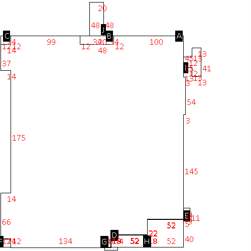 |
| Label |
Description |
Base SF |
Total SF |
| A |
INDUSTRIAL-LIGHT |
72606.00 |
72606.00 |
| B |
UTILITY STG-FR |
576.00 |
.00 |
| C |
PORCH-OPEN-FR |
168.00 |
.00 |
| D |
OFFICE BUILDING |
936.00 |
936.00 |
| E |
CANOPY-ECONOMY |
99.00 |
.00 |
| F |
PORCH-OPEN-FR |
168.00 |
.00 |
| G |
PORCH-OPEN-FR |
76.00 |
.00 |
| H |
OFFICE BUILDING |
2080.00 |
2080.00 |
| I |
CANOPY-ECONOMY |
713.00 |
.00 |
| J |
CANOPY,DET DRIVE-THRU |
960.00 |
.00 |
|
|
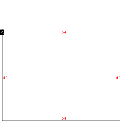
(Building 2) - Sketch for Parcel ID: 3722823743.000
NOTE: Sketches are updated the first day of every month.
 |
| Label |
Description |
Base SF |
Total SF |
| A |
WHSE |
14070.00 |
14070.00 |
| B |
UTILITY STG-FR |
410.00 |
.00 |
|
|
(Building 3) - Sketch for Parcel ID: 3722823743.000
NOTE: Sketches are updated the first day of every month.
 |
| Label |
Description |
Base SF |
Total SF |
| A |
OFFICE MODULAR/PANEL |
2268.00 |
2268.00 |
|
|
(Building 4) - Sketch for Parcel ID: 3722823743.000
NOTE: Sketches are updated the first day of every month.
 |
| Label |
Description |
Base SF |
Total SF |
| A |
SCHOOL-PUBLIC |
6840.00 |
6840.00 |
| B |
PORCH-OPEN-FR |
144.00 |
.00 |
|
|
(Building 5) - Sketch for Parcel ID: 3722823743.000
NOTE: Sketches are updated the first day of every month.
 |
| Label |
Description |
Base SF |
Total SF |
| A |
SCHOOL-PUBLIC |
25066.00 |
25066.00 |
|
|
|
|
|
| Map Acres |
9.13 |
| Tax District Note |
31 - C/CIWI-WILSON |
| Present-Use Info |
LIGHT MANUFACTURING |
| Zoning Code |
ICD |
| Zoning Desc |
INST CAMPUS DEVELOPMENT |
|
| Total Improvements Valuation
|
*Total Improvements Full Market Value $
|
**Total Improvements Assessed Value
|
10,282,119
|
10,282,119
|
*
Note - Market Value effective Date equal January 1, 2024, date of County’s most recent General
Reappraisal
** Note - If Assessed Value not equal Market Value then variance
resulting from formal appeal procedure |
|
| Land
Value Detail (Effective Date January 1, 2024, date
of County’s most recent General Reappraisal) |
Land
Full Value (LFV) $
|
Land
Present-Use Value (PUV) $ **
|
Land
Total Assessed Value $
|
223,707
|
223,707
|
223,707
|
| **
Note: If PUV equal LMV then parcel has
not qualified for present use program |
|
| Land
Detail (Effective Date January 1, 2024, date of County’s
most recent General Reappraisal) |
Rate Type |
Rate Code |
Description |
Quantity |
SF |
0600 |
INDUSTRIAL |
397702.800 |
|
|
|
.000 |
|
|
|
|
