| OAK PARK REALTY INVESTMENTS |
| LLC |
|
| 4737 YANK RD |
|
| WILSON , NC 27893 |
|
| Property
Location Address |
|
| Parcel
ID No. |
3619853541.000 |
| PIN |
3619 85 3541 000 |
| Owner ID |
69947765 |
| |
|
| Tax
District |
16 - C/SW/LEE WOODARD FD |
| |
| Land Use Code |
40 |
| Land Use Desc |
INDUSTRIAL |
| |
|
| Neighborhood |
8031 - BLACK_CREEK_TWP |
|
| Legal
Desc |
4737 YANK RD |
| |
L1 34.70AC |
| |
|
| Deed
Year Bk/Pg |
2017 - 1923 / 274 |
| Plat
Bk/Pg |
41 / 86 |
| |
Sales
Information |
| |
| Grantor |
|
| |
|
| Sold
Date |
0--0 |
| Sold
Amount $ |
0 |
|
| |
| Market Value $ |
5,211,206
|
| |
|
Market
Value - Land and all permanent improvements,
if any, effective January 1, 2024, date
of County’s most recent General Reappraisal
|
|
| |
|
| Assessed Value $ |
5,211,206
|
| |
If
Assessed Value not equal Market Value then
subject parcel designated as a special
class -agricultural, horticultural, or
forestland and thereby eligible for taxation
on basis of Present-Use.
|
|
|
| Year
Built |
1994 |
| Built
Use/Style |
INDUSTRIAL |
| Grade |
C-05 / C-05 GRADE |
| * Percent
Complete |
100 |
| Heated
Area (S/F) |
183,465 |
| Fireplace
(Y/N) |
N |
| Basement
(Y/N) |
N |
| ** Bedroom(s) |
0 |
| ** Bathroom(s) |
0 Full Bath(s) 0 Half Bath(s) |
| *** Multiple
Improvements |
004 |
*
Note - As of January 1
*
* Note - Bathroom(s), Bedroom(s), shown for description
only
* * * Note - If multiple improvements equal “MLT” then
parcel includes additional major improvements |
|
| Photo |
Photo 1
 Photo 2

|
|
| Building
Sketch - NOTE: Sketches are updated the first day of every month. |
|
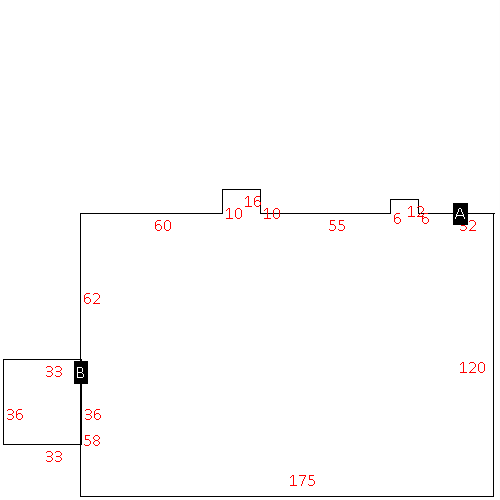
(Building 1) - Sketch for Parcel ID: 3619853541.000
NOTE: Sketches are updated the first day of every month.
 |
| Label |
Description |
Base SF |
Total SF |
| A |
INDUSTRIAL-LIGHT |
162540.00 |
162540.00 |
| B |
TRUCK WELL |
2700.00 |
.00 |
| C |
WHSE-OFFICE |
11125.00 |
11125.00 |
| D |
PORCH-OPEN-MAS |
144.00 |
.00 |
| E |
TRUCK WELL |
2700.00 |
.00 |
| F |
WHSE-OFFICE |
2300.00 |
2300.00 |
| G |
TRUCK WELL |
1980.00 |
.00 |
| H |
INDUSTRIAL-LIGHT |
7500.00 |
7500.00 |
|
|
(Building 2) - Sketch for Parcel ID: 3619853541.000
NOTE: Sketches are updated the first day of every month.
 |
| Label |
Description |
Base SF |
Total SF |
| A |
WHSE |
17200.00 |
17200.00 |
|
|
(Building 3) - Sketch for Parcel ID: 3619853541.000
NOTE: Sketches are updated the first day of every month.
 |
| Label |
Description |
Base SF |
Total SF |
| A |
WHSE |
21232.00 |
21232.00 |
| B |
TRUCK WELL |
1188.00 |
.00 |
|
|
(Building 4) - Sketch for Parcel ID: 3619853541.000
NOTE: Sketches are updated the first day of every month.
 |
| Label |
Description |
Base SF |
Total SF |
| A |
WHSE |
2500.00 |
2500.00 |
|
|
|
|
|
| Map Acres |
34.7 |
| Tax District Note |
16 - C/SW/LEE WOODARD FD |
| Present-Use Info |
INDUSTRIAL |
| Zoning Code |
M2 |
| Zoning Desc |
HEAVY INDUSTRIAL 20/100 |
|
| Total Improvements Valuation
|
*Total Improvements Full Market Value $
|
**Total Improvements Assessed Value
|
4,704,513
|
4,704,513
|
*
Note - Market Value effective Date equal January 1, 2024, date of County’s most recent General
Reappraisal
** Note - If Assessed Value not equal Market Value then variance
resulting from formal appeal procedure |
|
| Land
Value Detail (Effective Date January 1, 2024, date
of County’s most recent General Reappraisal) |
Land
Full Value (LFV) $
|
Land
Present-Use Value (PUV) $ **
|
Land
Total Assessed Value $
|
506,693
|
506,693
|
506,693
|
| **
Note: If PUV equal LMV then parcel has
not qualified for present use program |
|
| Land
Detail (Effective Date January 1, 2024, date of County’s
most recent General Reappraisal) |
Rate Type |
Rate Code |
Description |
Quantity |
AC |
0600 |
INDUSTRIAL |
18.000 |
|
|
|
.000 |
AC |
5010 |
RURAL HOMESITE PAVED |
1.930 |
|
|
|
.000 |
AC |
6111 |
MKT WOODS PVD CLASS 1 |
14.770 |
|
|
|
.000 |
|
|
|
|
