| EVANS BETH VICK |
| BRINKLEY MARGARET VICK |
|
| 6475 US 117 |
|
| LUCAMA , NC 27851 |
|
| Property
Location Address |
|
| Parcel
ID No. |
3607759369.000 |
| PIN |
3607 75 9369 000 |
| Owner ID |
1082456 |
| |
|
| Tax
District |
16 - C/SW/LEE WOODARD FD |
| |
| Land Use Code |
10 |
| Land Use Desc |
COMMERICAL |
| |
|
| Neighborhood |
8031 - BLACK_CREEK_TWP |
|
| Legal
Desc |
6485 US 117 HWY |
| |
115.32AC |
| |
|
| Deed
Year Bk/Pg |
2012 - 2011E / 21 |
| Plat
Bk/Pg |
/ |
| |
Sales
Information |
| |
| Grantor |
|
| |
|
| Sold
Date |
0--0 |
| Sold
Amount $ |
0 |
|
| |
| Market Value $ |
239,022
|
| |
|
Market
Value - Land and all permanent improvements,
if any, effective January 1, 2024, date
of County’s most recent General Reappraisal
|
|
| |
|
| Assessed Value $ |
112,958
|
| |
If
Assessed Value not equal Market Value then
subject parcel designated as a special
class -agricultural, horticultural, or
forestland and thereby eligible for taxation
on basis of Present-Use.
|
|
|
| Year
Built |
1934 |
| Built
Use/Style |
COMMERCIAL |
| Grade |
D-05 / D-05 GRADE |
| * Percent
Complete |
100 |
| Heated
Area (S/F) |
982 |
| Fireplace
(Y/N) |
N |
| Basement
(Y/N) |
N |
| ** Bedroom(s) |
0 |
| ** Bathroom(s) |
0 Full Bath(s) 0 Half Bath(s) |
| *** Multiple
Improvements |
001 |
*
Note - As of January 1
*
* Note - Bathroom(s), Bedroom(s), shown for description
only
* * * Note - If multiple improvements equal “MLT” then
parcel includes additional major improvements |
|
| Photo |
Photo 1

|
|
| Building
Sketch - NOTE: Sketches are updated the first day of every month. |
|
(Building 1) - Sketch for Parcel ID: 3607759369.000
NOTE: Sketches are updated the first day of every month.
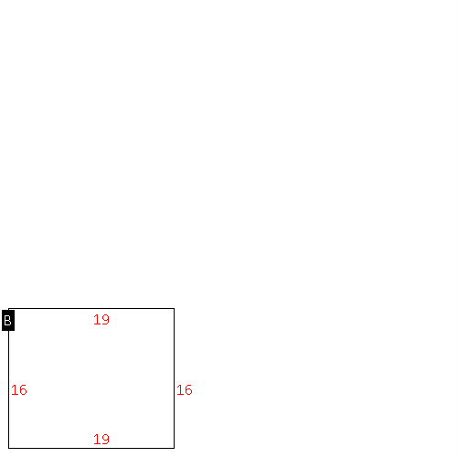 |
| Label |
Description |
Base SF |
Total SF |
|
|
(Building 2) - Sketch for Parcel ID: 3607759369.000
NOTE: Sketches are updated the first day of every month.
 |
| Label |
Description |
Base SF |
Total SF |
|
|
|
|
|
| Map Acres |
115.32 |
| Tax District Note |
16 - C/SW/LEE WOODARD FD |
| Present-Use Info |
COMMERICAL |
| Zoning Code |
AR |
| Zoning Desc |
AGRICUL-RESID 40M SF |
|
| Total Improvements Valuation
|
*Total Improvements Full Market Value $
|
**Total Improvements Assessed Value
|
12,626
|
12,626
|
*
Note - Market Value effective Date equal January 1, 2024, date of County’s most recent General
Reappraisal
** Note - If Assessed Value not equal Market Value then variance
resulting from formal appeal procedure |
|
| Land
Value Detail (Effective Date January 1, 2024, date
of County’s most recent General Reappraisal) |
Land
Full Value (LFV) $
|
Land
Present-Use Value (PUV) $ **
|
Land
Total Assessed Value $
|
226,396
|
100,332
|
100,332
|
| **
Note: If PUV equal LMV then parcel has
not qualified for present use program |
|
| Land
Detail (Effective Date January 1, 2024, date of County’s
most recent General Reappraisal) |
Rate Type |
Rate Code |
Description |
Quantity |
AC |
0700 |
COMMERCIAL |
1.000 |
|
|
|
.000 |
AC |
5111 |
MKT OPEN LD PVD CLASS 1 |
35.010 |
LU |
5110 |
|
35.010 |
AC |
5211 |
MKT OPEN LD PVD CLASS 2 |
18.900 |
LU |
5210 |
|
18.900 |
AC |
6111 |
MKT WOODS PVD CLASS 1 |
12.010 |
LU |
6110 |
|
12.010 |
AC |
6211 |
MKT WOODS PVD CLASS 2 |
8.950 |
LU |
6210 |
|
8.950 |
AC |
6311 |
MKT WOODS PVD CLASS 3 |
39.450 |
LU |
6310 |
|
39.450 |
|
|
|
|
