|
|
| 700 CRESTVIEW AVE SW |
|
| WILSON , NC 27893-4512 |
|
| Property
Location Address |
|
| Parcel
ID No. |
3619346669.000 |
| PIN |
3619 34 6669 000 |
| Owner ID |
1086096 |
| |
Future Transfer |
| Tax
District |
16 - C/SW/LEE WOODARD FD |
| |
| Land Use Code |
25 |
| Land Use Desc |
COMM/SERVICE |
| |
|
| Neighborhood |
8031 - BLACK_CREEK_TWP |
|
| Legal
Desc |
4560 US 117 HWY |
| |
.97AC |
| |
|
| Deed
Year Bk/Pg |
2021 - 2011 / CDTH |
| Plat
Bk/Pg |
/ |
| |
Sales
Information |
| |
| Grantor |
HAYES ALBERT ALLEN SR |
| |
|
| Sold
Date |
2024-01-24 |
| Sold
Amount $ |
170,000 |
|
| |
| Market Value $ |
133,253
|
| |
|
Market
Value - Land and all permanent improvements,
if any, effective January 1, 2024, date
of County’s most recent General Reappraisal
|
|
| |
|
| Assessed Value $ |
133,253
|
| |
If
Assessed Value not equal Market Value then
subject parcel designated as a special
class -agricultural, horticultural, or
forestland and thereby eligible for taxation
on basis of Present-Use.
|
|
|
| Year
Built |
1990 |
| Built
Use/Style |
COMM/SERVICE SHOP |
| Grade |
E+10 / E+10 GRADE |
| * Percent
Complete |
100 |
| Heated
Area (S/F) |
3,440 |
| Fireplace
(Y/N) |
N |
| Basement
(Y/N) |
N |
| ** Bedroom(s) |
0 |
| ** Bathroom(s) |
0 Full Bath(s) 0 Half Bath(s) |
| *** Multiple
Improvements |
003 |
*
Note - As of January 1
*
* Note - Bathroom(s), Bedroom(s), shown for description
only
* * * Note - If multiple improvements equal “MLT” then
parcel includes additional major improvements |
|
| Building
Sketch - NOTE: Sketches are updated the first day of every month. |
|
(Building 1) - Sketch for Parcel ID: 3619346669.000
NOTE: Sketches are updated the first day of every month.
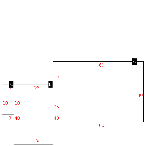 |
| Label |
Description |
Base SF |
Total SF |
| A |
COMMERCIAL/SERVICE |
2400.00 |
2400.00 |
| B |
STORE DISPLAY |
1040.00 |
1040.00 |
| C |
UTILITY STG-FR |
160.00 |
.00 |
|
|
(Building 2) - Sketch for Parcel ID: 3619346669.000
NOTE: Sketches are updated the first day of every month.
 |
| Label |
Description |
Base SF |
Total SF |
| A |
COMMERCIAL-MISC |
1073.00 |
1073.00 |
| B |
DECK-WOOD |
168.00 |
.00 |
| C |
PORCH-OPEN-MAS |
294.00 |
.00 |
| D |
STORE DISPLAY |
544.00 |
544.00 |
|
|
(Building 3) - Sketch for Parcel ID: 3619346669.000
NOTE: Sketches are updated the first day of every month.
 |
| Label |
Description |
Base SF |
Total SF |
| A |
WHSE |
1600.00 |
1600.00 |
|
|
|
|
|
| Map Acres |
0.97 |
| Tax District Note |
16 - C/SW/LEE WOODARD FD |
| Present-Use Info |
COMM/SERVICE |
| Zoning Code |
AR |
| Zoning Desc |
AGRICUL-RESID 40M SF |
|
| Total Improvements Valuation
|
*Total Improvements Full Market Value $
|
**Total Improvements Assessed Value
|
108,518
|
108,518
|
*
Note - Market Value effective Date equal January 1, 2024, date of County’s most recent General
Reappraisal
** Note - If Assessed Value not equal Market Value then variance
resulting from formal appeal procedure |
|
| Land
Value Detail (Effective Date January 1, 2024, date
of County’s most recent General Reappraisal) |
Land
Full Value (LFV) $
|
Land
Present-Use Value (PUV) $ **
|
Land
Total Assessed Value $
|
24,735
|
24,735
|
24,735
|
| **
Note: If PUV equal LMV then parcel has
not qualified for present use program |
|
| Land
Detail (Effective Date January 1, 2024, date of County’s
most recent General Reappraisal) |
Rate Type |
Rate Code |
Description |
Quantity |
AC |
0700 |
COMMERCIAL |
.970 |
|
|
|
.000 |
|
|
|
|


