| MOSLEY ANNIE RUTH LEWIS (LER) |
| |
|
| 5614 THOMPSON CHAPEL CHURCH RD |
|
| WILSON , NC 27896-8157 |
|
| Property
Location Address |
| 5614 THOMPSON CHAPEL CHURCH RD |
|
| Parcel
ID No. |
3715014525.000 |
| PIN |
3715 01 4525 000 |
| Previous Parcel |
3715014837.000 |
| Owner ID |
1113450 |
| |
|
| Tax
District |
14 - C/SW/SILVER LAKE FD |
| |
| Land Use Code |
50 |
| Land Use Desc |
RURAL HOMESITE |
| |
|
| Neighborhood |
8311 - TAYLORS |
|
| Legal
Desc |
5614 THOMPSON CHAPEL CH R |
| |
L1S2 2.02AC |
| |
|
| Deed
Year Bk/Pg |
2018 - 2746 / 916 |
| Plat
Bk/Pg |
20 / 92 |
| |
Sales
Information |
| |
| Grantor |
|
| |
|
| Sold
Date |
2018-06-14 |
| Sold
Amount $ |
0 |
|
| |
| Market Value $ |
283,190
|
| |
|
Market
Value - Land and all permanent improvements,
if any, effective January 1, 2024, date
of County’s most recent General Reappraisal
|
|
| |
|
| Assessed Value $ |
283,190
|
| |
If
Assessed Value not equal Market Value then
subject parcel designated as a special
class -agricultural, horticultural, or
forestland and thereby eligible for taxation
on basis of Present-Use.
|
|
|
| Year
Built |
1993 |
| Built
Use/Style |
SFR-UPTO 1.5 STY |
| Grade |
C+05 / C+05 GRADE |
| * Percent
Complete |
100 |
| Heated
Area (S/F) |
2,277 |
| Fireplace
(Y/N) |
Y |
| Basement
(Y/N) |
N |
| ** Bedroom(s) |
3 |
| ** Bathroom(s) |
2 Full Bath(s) 0 Half Bath(s) |
| *** Multiple
Improvements |
001 |
*
Note - As of January 1
*
* Note - Bathroom(s), Bedroom(s), shown for description
only
* * * Note - If multiple improvements equal “MLT” then
parcel includes additional major improvements |
|
| Photo |
Photo 1
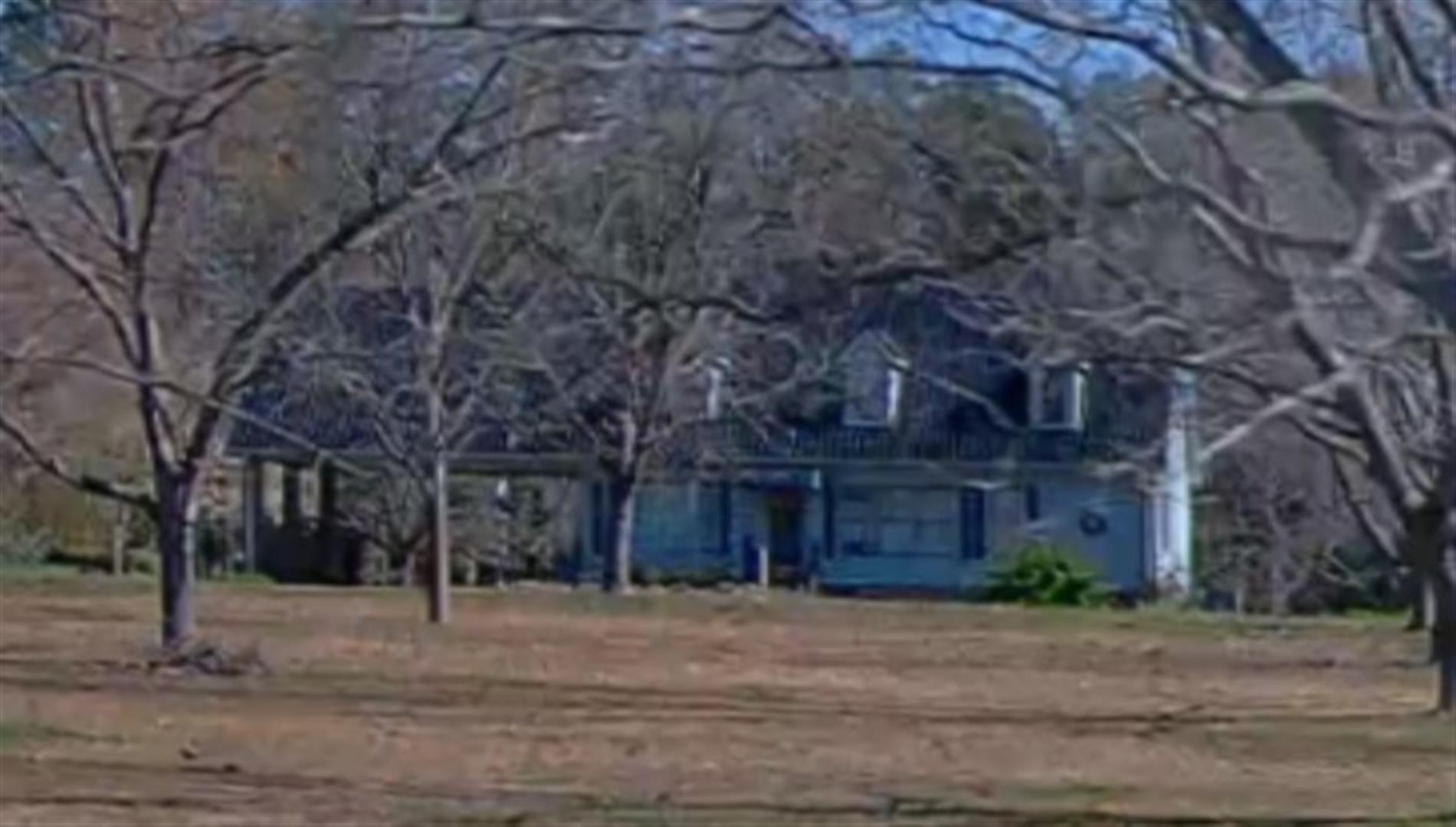
|
|
| Building
Sketch - NOTE: Sketches are updated the first day of every month. |
|
(Building 1) - Sketch for Parcel ID: 3715014525.000
NOTE: Sketches are updated the first day of every month.
 |
| Label |
Description |
Base SF |
Total SF |
| A |
SFR-1.5 STY |
1294.00 |
2277.00 |
| B |
CARPORT |
552.00 |
.00 |
| C |
PORCH-OPEN-MAS |
114.00 |
.00 |
| F |
STOOP-MAS |
24.00 |
.00 |
|
|
|
|
|
| Map Acres |
2.02 |
| Tax District Note |
14 - C/SW/SILVER LAKE FD |
| Present-Use Info |
RURAL HOMESITE |
| Zoning Code |
AR |
| Zoning Desc |
AGRICUL-RESID 40M SF |
|
| Total Improvements Valuation
|
*Total Improvements Full Market Value $
|
**Total Improvements Assessed Value
|
238,659
|
238,659
|
*
Note - Market Value effective Date equal January 1, 2024, date of County’s most recent General
Reappraisal
** Note - If Assessed Value not equal Market Value then variance
resulting from formal appeal procedure |
|
| Land
Value Detail (Effective Date January 1, 2024, date
of County’s most recent General Reappraisal) |
Land
Full Value (LFV) $
|
Land
Present-Use Value (PUV) $ **
|
Land
Total Assessed Value $
|
44,531
|
44,531
|
44,531
|
| **
Note: If PUV equal LMV then parcel has
not qualified for present use program |
|
| Land
Detail (Effective Date January 1, 2024, date of County’s
most recent General Reappraisal) |
Rate Type |
Rate Code |
Description |
Quantity |
AC |
5010 |
RURAL HOMESITE PAVED |
1.000 |
|
|
|
.000 |
AC |
0121 |
RESIDUAL ACREAGE PAVED |
1.020 |
|
|
|
.000 |
|
|
|
|
