|
|
| 964 HIGH HOUSE RD |
UNIT 4112 |
| CARY , NC 27513 |
|
| Property
Location Address |
|
| Parcel
ID No. |
3722313657.000 |
| PIN |
3722 31 3657 000 |
| Owner ID |
1132131 |
| |
|
| Tax
District |
31 - C/CIWI-WILSON |
| |
| Land Use Code |
62 |
| Land Use Desc |
DUPLEX/TRIPLEX |
| |
|
| Neighborhood |
8196 - NASH_B-2 |
|
| Legal
Desc |
203 PINE ST NE |
| |
1.00LT |
| |
|
| Deed
Year Bk/Pg |
2023 - 3040 / 225 |
| Plat
Bk/Pg |
/ |
| |
Sales
Information |
| |
| Grantor |
RASHED HARUN O |
| |
|
| Sold
Date |
2023-11-14 |
| Sold
Amount $ |
65,000 |
|
| |
| Market Value $ |
69,292
|
| |
|
Market
Value - Land and all permanent improvements,
if any, effective January 1, 2024, date
of County’s most recent General Reappraisal
|
|
| |
|
| Assessed Value $ |
69,292
|
| |
If
Assessed Value not equal Market Value then
subject parcel designated as a special
class -agricultural, horticultural, or
forestland and thereby eligible for taxation
on basis of Present-Use.
|
|
|
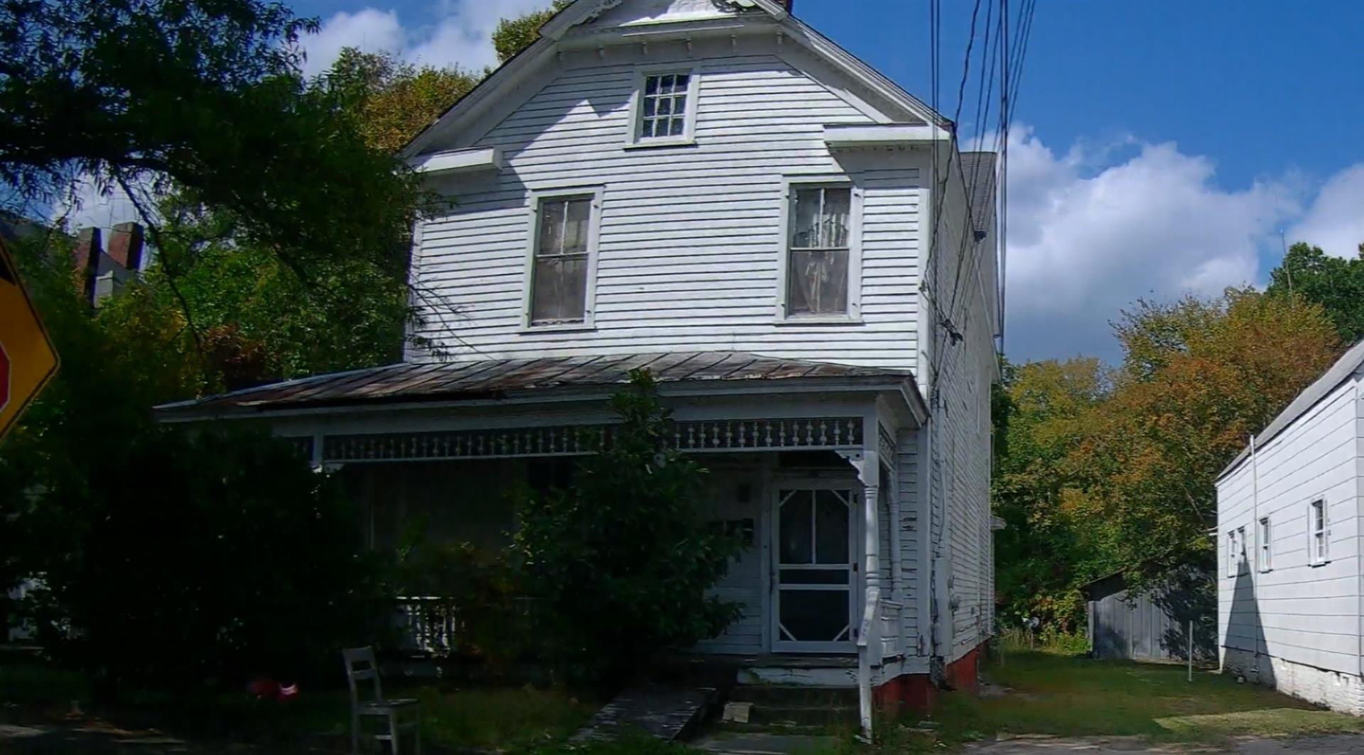
| Year
Built |
1900 |
| Built
Use/Style |
APARTMENT-DUPLEX/TRIPLEX |
| Grade |
D / D GRADE |
| * Percent
Complete |
100 |
| Heated
Area (S/F) |
2,769 |
| Fireplace
(Y/N) |
Y |
| Basement
(Y/N) |
N |
| ** Bedroom(s) |
0 |
| ** Bathroom(s) |
0 Full Bath(s) 0 Half Bath(s) |
| *** Multiple
Improvements |
001 |
*
Note - As of January 1
*
* Note - Bathroom(s), Bedroom(s), shown for description
only
* * * Note - If multiple improvements equal “MLT” then
parcel includes additional major improvements |
|
| Photo |
Photo 1
|
|
| Building
Sketch - NOTE: Sketches are updated the first day of every month. |
|
(Building 1) - Sketch for Parcel ID: 3722313657.000
NOTE: Sketches are updated the first day of every month.
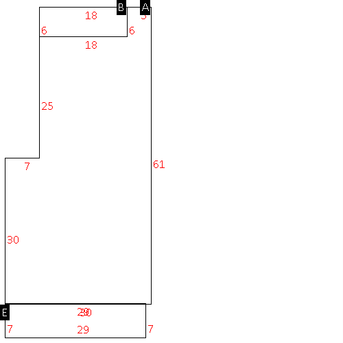 |
| Label |
Description |
Base SF |
Total SF |
| A |
APT-DUPLEX/TRIPLEX |
1505.00 |
2769.00 |
| B |
PORCH-OPEN-FR |
108.00 |
.00 |
| E |
PORCH-OPEN-FR |
203.00 |
.00 |
|
|
|
|
|
| Map Acres |
0.138 |
| Tax District Note |
31 - C/CIWI-WILSON |
| Present-Use Info |
DUPLEX/TRIPLEX |
| Zoning Code |
NMX |
| Zoning Desc |
NBRHD MIXED USE |
|
| Total Improvements Valuation
|
*Total Improvements Full Market Value $
|
**Total Improvements Assessed Value
|
56,690
|
56,690
|
*
Note - Market Value effective Date equal January 1, 2024, date of County’s most recent General
Reappraisal
** Note - If Assessed Value not equal Market Value then variance
resulting from formal appeal procedure |
|
| Land
Value Detail (Effective Date January 1, 2024, date
of County’s most recent General Reappraisal) |
Land
Full Value (LFV) $
|
Land
Present-Use Value (PUV) $ **
|
Land
Total Assessed Value $
|
12,602
|
12,602
|
12,602
|
| **
Note: If PUV equal LMV then parcel has
not qualified for present use program |
|
| Land
Detail (Effective Date January 1, 2024, date of County’s
most recent General Reappraisal) |
Rate Type |
Rate Code |
Description |
Quantity |
SF |
0560 |
MULTI-FAMILY GARDEN |
6030.000 |
|
|
|
.000 |
|
|
|
|
