| ROBERSON STEVEN WAYNE |
| ROBERSON LESLI CARROLL |
|
| PO BOX 493 |
|
| BLACK CREEK , NC 27813-0493 |
|
| Property
Location Address |
|
| Parcel
ID No. |
3618177537.000 |
| PIN |
3618 17 7537 000 |
| Owner ID |
69942622 |
| |
Future Transfer |
| Tax
District |
16 - C/SW/LEE WOODARD FD |
| |
| Land Use Code |
50 |
| Land Use Desc |
RURAL HOMESITE |
| |
|
| Neighborhood |
8030 - BLACK_CREEK_RA |
|
| Legal
Desc |
5362 US 117 HWY |
| |
TR-1 FERRELL LD 56.74AC |
| |
|
| Deed
Year Bk/Pg |
2000 - 1785 / 482 |
| Plat
Bk/Pg |
10 / 122 |
| |
Sales
Information |
| |
| Grantor |
ROBERSON STEVEN WAYNE |
| |
ROBERSON LESLI CARROLL |
| Sold
Date |
2024-01-25 |
| Sold
Amount $ |
800,000 |
|
| |
| Market Value $ |
592,276
|
| |
|
Market
Value - Land and all permanent improvements,
if any, effective January 1, 2024, date
of County’s most recent General Reappraisal
|
|
| |
|
| Assessed Value $ |
592,276
|
| |
If
Assessed Value not equal Market Value then
subject parcel designated as a special
class -agricultural, horticultural, or
forestland and thereby eligible for taxation
on basis of Present-Use.
|
|
|
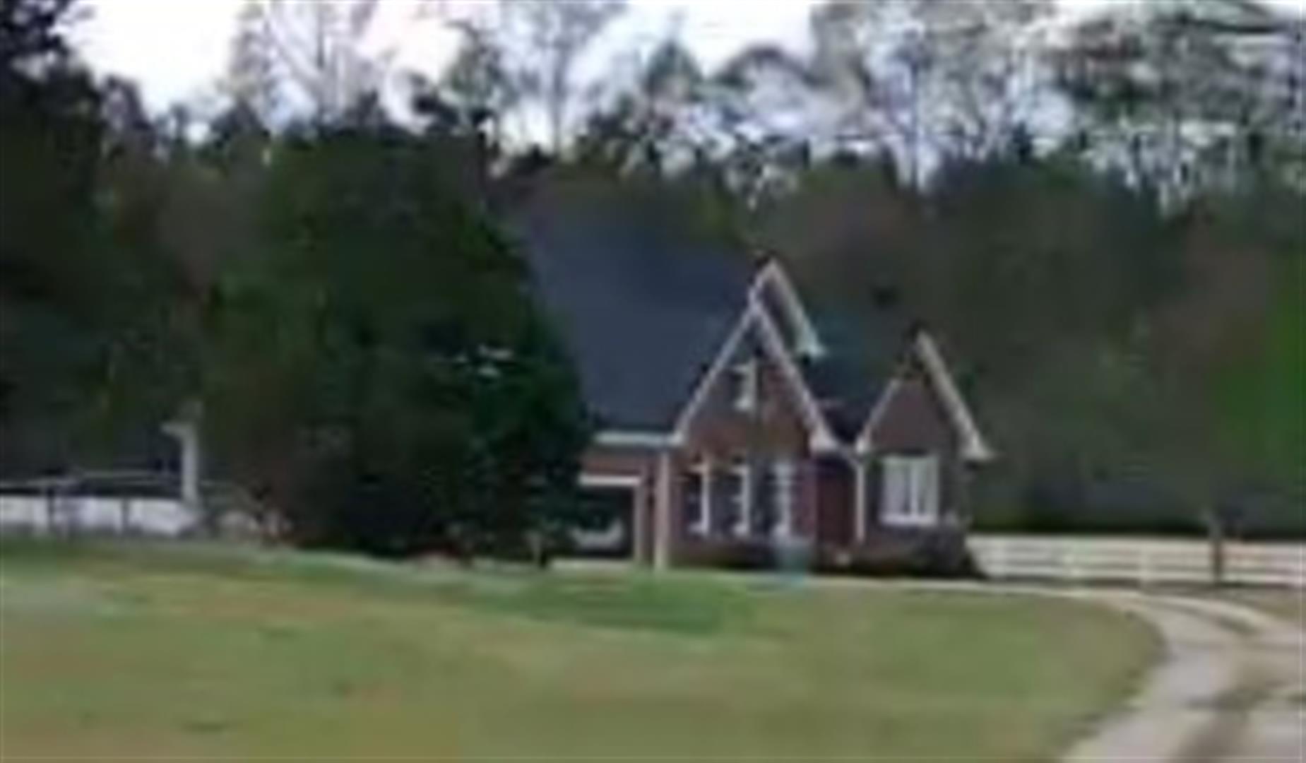
| Year
Built |
2000 |
| Built
Use/Style |
SFR-UPTO 1.5 STY |
| Grade |
B+05 / B+05 GRADE |
| * Percent
Complete |
100 |
| Heated
Area (S/F) |
3,070 |
| Fireplace
(Y/N) |
Y |
| Basement
(Y/N) |
N |
| ** Bedroom(s) |
3 |
| ** Bathroom(s) |
3 Full Bath(s) 1 Half Bath(s) |
| *** Multiple
Improvements |
001 |
*
Note - As of January 1
*
* Note - Bathroom(s), Bedroom(s), shown for description
only
* * * Note - If multiple improvements equal “MLT” then
parcel includes additional major improvements |
|
| Photo |
Photo 1
 Photo 2
|
|
| Building
Sketch - NOTE: Sketches are updated the first day of every month. |
|
(Building 1) - Sketch for Parcel ID: 3618177537.000
NOTE: Sketches are updated the first day of every month.
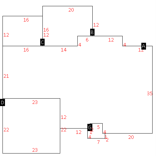 |
| Label |
Description |
Base SF |
Total SF |
| A |
SFR-1.5 STY |
1806.00 |
3161.00 |
| B |
DECK-WOOD |
296.00 |
.00 |
| C |
PORCH-OPEN-MAS |
192.00 |
.00 |
| D |
GARAGE-ATT-MAS |
506.00 |
.00 |
| G |
STOOP-MAS |
36.00 |
.00 |
|
|
|
|
|
| Map Acres |
56.74 |
| Tax District Note |
16 - C/SW/LEE WOODARD FD |
| Present-Use Info |
RURAL HOMESITE |
| Zoning Code |
RA |
| Zoning Desc |
RESIDENTAL AGRICULTURAL |
|
| Total Improvements Valuation
|
*Total Improvements Full Market Value $
|
**Total Improvements Assessed Value
|
471,092
|
471,092
|
*
Note - Market Value effective Date equal January 1, 2024, date of County’s most recent General
Reappraisal
** Note - If Assessed Value not equal Market Value then variance
resulting from formal appeal procedure |
|
| Land
Value Detail (Effective Date January 1, 2024, date
of County’s most recent General Reappraisal) |
Land
Full Value (LFV) $
|
Land
Present-Use Value (PUV) $ **
|
Land
Total Assessed Value $
|
121,184
|
121,184
|
121,184
|
| **
Note: If PUV equal LMV then parcel has
not qualified for present use program |
|
| Land
Detail (Effective Date January 1, 2024, date of County’s
most recent General Reappraisal) |
Rate Type |
Rate Code |
Description |
Quantity |
AC |
5010 |
RURAL HOMESITE PAVED |
2.000 |
|
|
|
.000 |
AC |
5111 |
MKT OPEN LD PVD CLASS 1 |
14.890 |
|
|
|
.000 |
AC |
5411 |
MKT OPEN LD PVD CLASS 4 |
1.850 |
|
|
|
.000 |
AC |
6111 |
MKT WOODS PVD CLASS 1 |
21.500 |
|
|
|
.000 |
AC |
6211 |
MKT WOODS PVD CLASS 2 |
3.500 |
|
|
|
.000 |
AC |
6311 |
MKT WOODS PVD CLASS 3 |
13.000 |
|
|
|
.000 |
|
|
|
|
